
Home > Research > Research Results > Research Results 2018 > Development of an efficient method to estimate tropical forest biomass with high-resolution remote sensing
Update:June 11, 2018
Main content starts here.
Development of an efficient method to estimate tropical forest biomass with high-resolution remote sensing
| Article title |
Object-based mapping of aboveground biomass in tropical forests using LiDAR and very-high-spatial-resolution satellite data |
|---|---|
| Author (affiliation) |
Yasumasa Hirata (a), Naoyuki Furuya (b), Hideki Saito (c), Chealy Pak (d), Chivin Leng (e), Heng Sokh (f), Vuthy Ma (f), Tsuyoshi Kajisa (g), Tetsuji Ota (h), Nobuya Mizoue (h) (a) Principal Research Director, FFPRI, Tsukuba, Ibaraki, Japan. (c) Department of Forest Management, FFPRI, Tsukuba, Ibaraki, Japan. (d) Forestry Administration, Preah Norodom Blvd, Phnom Penh, Cambodia. (e) Ministry of Environment, Chamkarmon, Phnom Penh, Cambodia. (f) Forest-Wildlife Research and Development Institute, Forestry Administration, Khan Sen Sok, Phnom Penh, Cambodia. (g) Kagoshima University, Korimoto, Kagoshima, Japan. (h) Kyushu University, Hakozaki, Fukuoka, Japan. |
| Publication Journal |
Remote Sensing, 10(3); 48 (21 pp.), March 2018, DOI: 10.3390/rs10030438( External link ) |
| Content introduction |
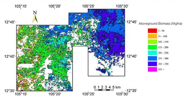
Deforestation and forest degradation in tropical regions are the major causes of climate change. Therefore, as part of United Nations initiative, a framework to curb deforestation and forest degradation in developing countries, called the REDD-plus, was created. A scientific approach is necessary to evaluate the amount by which deforestation- and forest degradation-related carbon dioxide emissions were reduced as a result of implementing REDD-plus. Until recently, the standard method has been to first calculate the change in forest area using remote sensing and then calculate the carbon stock per unit area from biomass through ground surveys. However, there have been problems in obtaining sufficient ground survey data at the national level due to the difficulty of accessing forests as well as limitations in human resources. Therefore, instead of conducting a ground survey at the national level, we developed a method to estimate forest biomass by area and forest type using an airborne LiDAR (see Note), which can obtain high-definition forest information, and high-resolution satellite. First, we estimated the forest biomass over a limited area using an airborne laser scanner, which is an expensive but accurate technique. Next, we estimated forest biomass over a wider area by creating a model that uses this estimate of the limited area to extrapolate a forest biomass from high-resolution satellite data, which is cheaper to obtain than using an airborne laser scanner. Thus, it is possible to efficiently estimate forest biomass by area and forest type instead of ground surveys. In turn, this is useful to estimate deforestation- and forest degradation-related carbon dioxide emissions, which is particularly helpful in developing countries where REDD-plus is implemented.
(Note) Airborne LiDAR: A system that reproduces a three-dimensional structure on the ground by irradiating tens of thousands of laser beams per second onto the ground from a laser scanner mounted on an aircraft.
Figure: Mapping of tropical forest biomass using airborne LiDAR and high-resolution satellite (Kompong Thom Province, Cambodia). |
Copyright © Forest Research and Management Organization. All rights reserved.