
Home > Research > Research Results > Research Results 2020 > Estimating Information Regarding Past Tsunamis from Tsunami Sedimentation Deposits
Update:March 11, 2020
Main content starts here.
Estimating Information Regarding Past Tsunamis from Tsunami Sedimentation Deposits
| Article title |
Numerical experiment for fault parameter estimates by the changing point of tsunami sand deposit distribution |
|---|---|
| Author (affiliation) |
Ako Yamamoto (a), Tomoyuki Takahashi (b), Kenji Harada (c) (a) Department of Disaster Prevention, Meteorology and Hydrology, FFPRI, Tsukuba, Ibaraki, Japan. (b) Kansai University, Takatsuki, Osaka, Japan. (c) Shizuoka University, Shizuoka, Japan. |
| Publication Journal |
J.JSCE, Ser.B2, Coastal engineering 75(2), p.l_361-l_366, October 2019 DOI:10.2208/kaigan.75.I_361( External link ) |
| Content introduction |
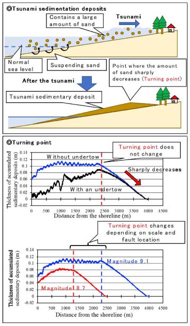
It is essential to estimate the scale and frequency of possible tsunamis to evaluate the disaster prevention and mitigation functions of coastal disaster prevention forests. However, it is difficult to estimate information regarding huge tsunamis that occur at intervals of hundreds to thousands of years using only the immediate data, which necessitates us to estimate the size and wave source of tsunamis that occurred many years ago. We found a method of estimating the magnitude of past tsunamis based on the accumulated tsunami sedimentation deposits i.e., the sediments transported by the tsunami. In the present study, tsunamis of various magnitudes were generated on a simulated terrain (the Nankai Earthquake Tsunami was estimated) using numerical simulations, and we considered whether the scale and wave could be estimated from the characteristics of the resulting tsunami sedimentation deposits. As a result of the simulation, the point where the thickness of the sand layer of tsunami sediments rapidly decreased from the sea to the back of the land (hereinafter, the turning point) was confirmed. It was found that the turning point is formed under certain flow conditions and particle size, and it does not change if caught in an undertow. The tsunami’s reach to land side and the wave height at the coast can be estimated from the location of the turning point. Further, the location of the turning point together with the thickness of the sand layer provides information for obtaining clues regarding tsunamis with respect to their scales and the distance from the faults. Moreover, the numerical simulations suggested that the accuracy of scale estimation improved using multiple points of sand thickness. Further improvement and validation will be required in the future. However, the present simulation enables the prediction of giant tsunamis in the future based on the information regarding past tsunamis using tsunami sedimentation deposits. This, in turn, will provide important information for the maintenance and management of a durable coastal disaster prevention forest.
|
Copyright © Forest Research and Management Organization. All rights reserved.