
Home > Research > Research Results > Research Results 2020 > Depicting the high-resolution risk map of pine wilt disease useful for disease risk prevention and management
Update:June 17, 2020
Main content starts here.
Depicting the high-resolution risk map of pine wilt disease useful for disease risk prevention and management
| Article title |
Developing a point process model for ecological risk assessment of pine wilt disease at multiple scales |
|---|---|
| Author (affiliation) |
Saeko Matsuhashi (a)(b), Akiko Hirata (c), Mitsuteru Akiba (d), Katsunori Nakamura (e), Michio Oguro (f), Kohei Takenaka Takano (g), Katsuhiro Nakao (h), Yasuaki Hijioka (c), Tetsuya Matsui (b) (a) National Agriculture and Food Research Organization, Tsukuba, Ibaraki, Japan. (b) Center for International Partnerships and Research on Climate Change, FFPRI, Tsukuba, Ibaraki, Japan. (c) National Institute for Environmental Studies, Tsukuba, Ibaraki, Japan. (d) Department of Mushroom Science and Forest Microbiology, FFPRI, Tsukuba, Ibaraki, Japan. (e) Tohoku Research Center, FFPRI, Morioka, Iwate, Japan. (f) Department of Forest Vegetation, FFPRI, Tsukuba, Ibaraki, Japan. (g) Nagano Environmental Conservation Research Institute, Nagano, Japan. (h) Kansai Research Center,FFPRI, Kyoto, Japan. |
| Publication Journal |
Forest Ecology and Management, Elsevier B.V., March 2020, DOI:10.1016/j.foreco.2020.118010( External link ) |
| Content introduction |
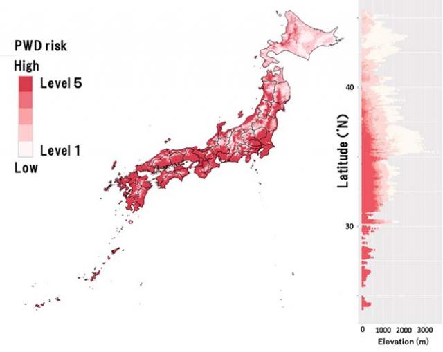
Pine wilt disease (PWD) has been causing serious damage to pine forests in Japan. While it is not widespread in Hokkaido, it occurs throughout the other 46 prefectures of the country. In order to formulate effective long-term measures to prevent this disease, it is important to identify regions at high risk with high degrees of resolution and accuracy. In the present study, the latest statistical methods were used to create high-resolution (1km X 1km mesh size) maps of high-risk areas in the entire country (Fig. 1). According to these maps, the areas with the highest risk of pine wilt disease (Level 5) at the present time spread farther north than the border between Akita and Aomori prefectures, which is currently known as the northern border of PWD. It was also shown that areas with Level 5 spread to a higher elevational extent of 800 to 1,000m in inland Honshu. These findings, together with information about areas that are already experiencing widespread damage, signify the possibility of concentrated damage, even in cold and high-elevation regions for which there is relatively little information about damage. Furthermore, under climate change scenarios in which temperatures are expected to rise over a 25-year timeline (2026 to 2050), we could see that the areal extent of high-risk regions may increase by up to 60%. The risk map that is shown here can be utilized to formulate measures for protecting pine forests that are at the front lines of expanding damage and to create management plans for important pine forests throughout Japan. It can also be used for such purposes as formulating measures for adapting to the risks of disease and insect infestation that may occur in conjunction with climate change.
Figure 1: Horizontal and elevational distributions of current areas of pine wilt disease (PWD) that were estimated based on information about temperature, precipitation, and points where the disease occurs. Level 1 indicates low risk (conditions under which no PWD is observed) while Level 5 indicates high risk (conditions suitable for the spread of PWD). The highest elevational distribution of each level tends to decrease towards the north because of increasingly colder climate. (This figure was taken from the published study that is posted at https://doi.org/10.1016/j.foreco.2020.118010( External link )). |
Copyright © Forest Research and Management Organization. All rights reserved.