
Home > Research > Research Results > Research Results 2020 > The appearance of forests in the early Showa era comes back to life
Update:December 2, 2020
Main content starts here.
The appearance of forests in the early Showa era comes back to life.
- Reconfirmation of a report on a study of natural forests from roughly 90 years ago -
| Article title |
Discovering original research reports from government-owned natural forests in the early Showa era |
|---|---|
| Author (affiliation) |
Kaoru Niiyama (a), Mitsue Shibata (a), Hiroko Kurokawa (a), Tetsuya Matsui (b), Haruka Ohashi (c), Tamotsu Sato (a) (a) Department of Forest Vegetation, FFPRI, Tsukuba, Ibaraki, Japan. (b) Center for International Partnerships and Research on Climate Change, FFPRI, Tsukuba, Ibaraki, Japan. (c) Department of Wildlife Biology, FFPRI, Tsukuba, Ibaraki, Japan. |
| Publication Journal |
Publication Journal: Bulletin of FFPRI, Vol.19 No.3:274-324. October 2020 URL:https://www.ffpri.go.jp/pubs/bulletin/455/455toc-en.html |
| Content introduction |
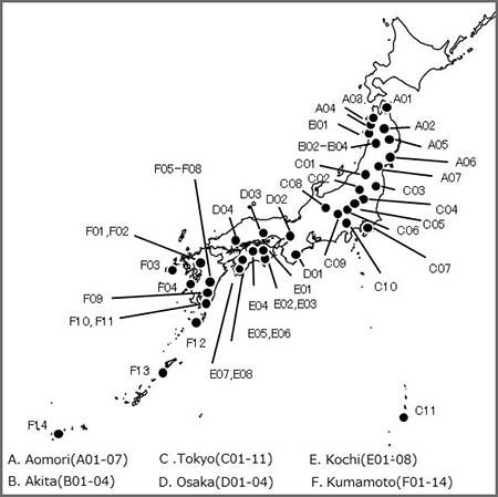
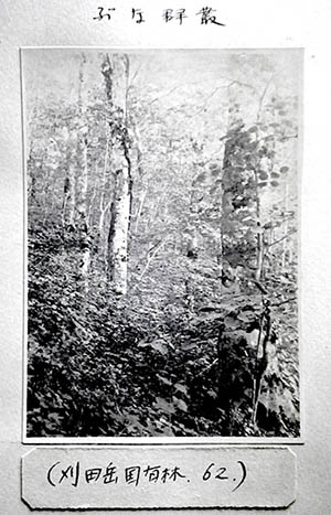
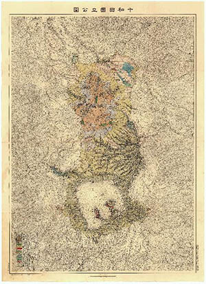
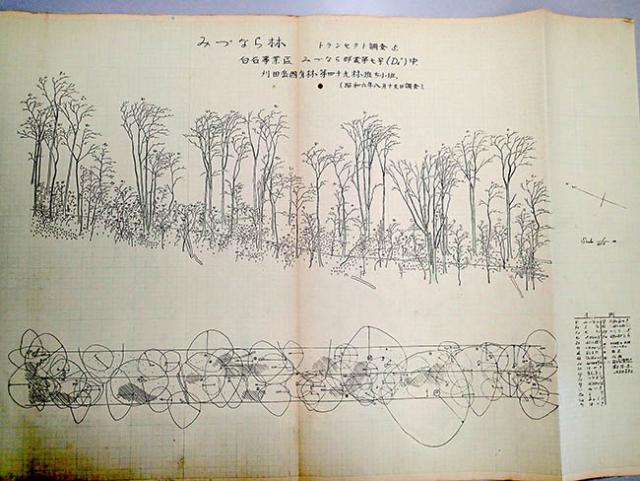
From among old materials that have been archived for many years, the Forestry and Forest Products Research Institute have been collating 662 source materials of major reports on forest surveys that were conducted on government-owned natural forests in the early Showa era, which began in 1926. These materials have been printed and released in an easy-to-understand catalog format. These valuable materials are a compilation of results of surveys that were conducted at the same time from Aomori to Kyushu and Yakushima Island during the early Showa era. While many of these forests may have been lost during and immediately after the Pacific War, these materials today provide us with a lot of vegetation data, detailed hand-drawn cross-sectional forest maps, huge original survey records of tree height and diameter, and photographs taken on location, among other things. This is a detailed, easy-to-understand catalog of valuable source materials that can provide a foundation for considering how Japan will approach forest management and the effects of global warming in the future. If surveys can be taken in the same locations, then we may be able to verify the effects that changes in climate and land use over the past 90 years have had on natural forests. From the early 1910s into the 1930s, natural regeneration in Japan was promoted by selective cutting, and the surveys of government-owned natural forests were conducted extensively under the initiatives of the Forestry Bureau, Ministry of Agriculture and Forestry. The tremendous amounts of materials of surveys conducted by 6 National Forest Regional Offices from Aomori to Kumamoto were submitted by each office to the Forestry Bureau as "Survey Reports on Government-owned Natural Forests", and some of the materials were published. However, due to the intensification of the war, not all of the materials were published. After the war, the survey materials were transferred to the Government Forest Experiment Station of the Forestry Agency (present-day FFPRI), and in the late 1940s to early 1950s, some of these materials were used as basic data in research papers written by staff of the Government Forest Experiment Station. After that, the focus of research shifted to artificial forests that were being cultivated to produce wood, and the pre-war natural forest survey materials were put into long-term storage. In the present project, when an inspection was made of materials that had been stored at the FFPRI, the large amounts of hand-written, hand-drawn materials which were the source materials for the above-mentioned "Survey Reports on Government-owned Natural Forests" had existed in fragmented form, so it was decided to arrange and compile them. In December 1926, the Forestry Bureau, Ministry of Agriculture and Forestry issued the "Methodology for Surveying Government-owned Natural Forests" that was written by Masaru Kawada who had been a renowned forest ecologist before the war. National Forest Regional Offices in each region used this methodology as a basis for conducting their surveys of natural forests and compiled them as "Survey Reports on Government-owned Natural Forests" (Fig. 1). As a result of the present collation, we could see that there were large differences among National Forest Regional Offices in the number of materials. That is, there were 75 materials from the Aomori, 11 materials from the Akita, 164 materials from the Tokyo, 19 materials from the Osaka, 139 materials from the Kochi, and 254 materials from the Kumamoto National Forest Regional Office. These materials contained numerous photo albums that reflected the physiognomy of natural forests of the time (Fig. 2: beech forest), detailed forest vegetation maps (Fig. 3: the area around Lake Towada), and detailed forest cross-sectional diagrams (Fig. 4: natural Quercus crispula forest), among other things. In addition, the vegetation survey of the Kochi was also a descriptive report involving renowned botanists of the time such as Dr. Tomitaro Makino. Plans call for these valuable materials to be systematically converted into a digital archive. In the present project, the materials of the "Survey Reports on Government-owned Natural Forests" that were made into catalog format are, in and of themselves, valuable as records of the state of natural forests before the period of massive forest plantation in the post-war era. Furthermore, if surveys can be conducted with the same methodology in the same locations of remaining natural forests, then it will be possible to reveal how forests have changed through succession due to climate change and land-use over the past 90 years. These materials will also be important as starting points for making comparisons even as we investigate what sorts of changes in the distribution, etc., of forests and plants will occur as global warming acceleration. Working with local researchers who have a keen interest in forests, and keeping data license in mind, we would like to develop research on a nationwide scale that utilizes materials from the early Showa era. If you have an interest in such joint research, please contact the research supervisor at the following exclusive e-mail address: <E-mail:showaforest@ml.affrc.go.jp>.
Figure 2. Photo album of the Aomori National Forest Regional Office : Example of a beech forest.
Figure 3. Forest vegetation map of the Aomori National Forest Regional Office : A very valuable hand-drawn and colored vegetation map of the area around Lake Towada.
Figure 4. Cross-sectional diagram and canopy projection of a Quercus crispula forest in the region of Aomori National Forest Regional Office. (Katsutadake National Forest, Shiroishi District, Miyagi Prefecture) |
Copyright © Forest Research and Management Organization. All rights reserved.